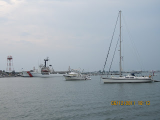
As we got underway this morning, we passed our neighbor, John Pilcicki, coming back in on his boat. He shot this photo of Aloha Friday on her way out!
 |
| Aloha Friday's Departure |
It was an absolutely outstanding day on the Chesapeake Bay! What does that mean? Light winds and little to no sea - just the way I like it. As we approached Annapolis, there were quite a few merchant ships anchored, waiting to take on cargo.
 |
| Annapolis - Merchant ships at anchor |
 |
| Looking East - Chesapeake Bay Bridge |
View Larger Map
Here's Clyde and Ted after our first day.
 |
| Ted & Clyde |
 |
| Clyde - 18 years old |
11 June 2011 Magothy River to Bohemia River, MD
Foggy when we left and foggy all day long. One of the new "toys" on our boat is a "receive-only" Automatic Identification System (AIS). It helps us identify and track large vessels. Here's a snapshot of the display on my PC. We are the green vessel. The downbound ship is the blue triangle just above us to the right. You'll need to see the full size photo to see us on the chart. Note the red block on the top left hand side of the screen. The information on a ship turns bright red when we are close.
We made our way up to the Bohemia River to Bohemia Bay Yacht Harbor to connect with MTOA friends, Bill & Jean Ahern. We stayed in a friend's slip for the night. Nice to plug in so we could turn on the AC! As you can see this area is pretty rural.
View Larger Map
Here's a preview of part of tomorrow's run through the C&D Canal and out the Delaware Bay.
View Larger Map
12 June 2011 Bohemia Bay, MD to Cape May, NJ
Another foggy morning...no complaints as it is cooler. Up at 0515 (ugh) to catch a fair current down the Delaware Bay. Several sailboats and one other trawler had the same idea. We're all running through the C&D Canal toward the Bay. This is only our second run out the Delaware Bay and we hit pay dirt with the weather. Light, west winds as we head east. Very nice!
The tug, Beaufort Sea, with her tow....
Ship John Shoal on the east side of Delaware Bay - named after the Ship "John" - wrecked in 1787 near the site of the present structure.
As we approached max ebb on the Bay we found ourselves traveling well over 9 kts; as high as 9.7kts. What a nice ride. By noon the sun had broken out and we're surrounded by blue skies.
We anchored just off the U.S. Coast Guard Base in Cape May. The anchorage area is in a No Wake Zone but not everyone seems to know this. All and all, it was a pretty good anchorage with a few wakes.
 |
| USCG Ship, Defever 44+5, New Zealand sailboat |
 |
| USCG 47' Motor Life Boat |
View Larger Map
13 June 2011 Cape May to Atlantic City, NJ
Our first run offshore today was just an "OK" ride. I tried out my scopalamine patches and they worked like a charm. As the seas picked up closer to noon we decided to duck in at Atlantic City. At one point during the day I put polartec socks on the wine glasses to keep them from clinking.
 |
| Socks on wine glasses |
View Larger Map
14 June 2011 Atlantic City to Barnegat, NJ
A few shots of Atlantic City as we departed Absecon Inlet.
 |
| Harrah's |
 |
| The Water Club |
 |
| Downtown Atlantic City |
View Larger Map
15 June 2011 Barnegat to Manasquan Inlet, NJ
We've pretty much had all north winds on this offshore portion of the trip. Sometimes we can find a smoother ride a little farther out in deeper water. We considered picking up the NJ ICW from Barnegat but passed on that as well. We have the play the tides if we want to run the ICW from Barnegat to Manasquan. After Manasquan you have no choice but to run the last leg to Sandy Hook or NY on the outside.
Stopping in Manasquan gives us the opportunity to visit a long time friend of ours that we haven't seen in 2 years. We took on fuel at Hoffman's Marina ($3.79/gal) before we moving into the slip. As the current runs pretty fast in this area, the owner asked if he could move our boat into the slip. Ted didn't have a problem with that. Before we departed the fuel dock, I got out more lines. The finger piers are short - I don't like short, narrow finger piers. That evening, as the full moon approached, we had 6" of water on the finger piers. Did I mention that the NJ transit commuter trains passed right behind the marina?
 |
| NJ Transit train |
 |
| Mako shark for dinner |
 |
| Current on the piling - line underwater at high tide |
 |
| Led, Ted, Lois & Tom |
View Larger Map


No comments:
Post a Comment