Wednesday, October 26, 2011

11 August - 6 September 2011 Nova Scotia Cruising Part 1

Nova Scotia

From PEI we headed  down Northumberland Strait, east to Cape Breton Island and then south along the Nova Scotia coast as far as Yarmouth.


11 Aug 2011  0705-1601  Charlottetown, PEI to Ballantyne's Cove, Nova Scotia  67 nm

Did I mention that the ice machine broke around 5 August?  It sits up on the deck above our stateroom.   I can hear it dump ice and fill.  One night it seemed to me that I heard it filling more than dumping.  The next morning I looked and the bin was a frozen block of ice with cubes inside it and the bin was frozen to the bottom of the ice machine.  It is difficult to find parts in Canada so we figured we'd just fix it when we got home.

Ballantyne's Cove is situated in a rural setting and is home to a small fishing community.  When its bluefin tuna season, this place becomes a beehive of activity and a principal trading point for Japanese merchants looking for sushi-grade tuna.  If you're a fisherman, this is where the world record Blue fin tuna was caught via rod and reel. It weighed something like 1485 lbs and was caught on a 133 lb test line!

Entering Ballantyne's Cove
Power in the marina

Jim & Mary Fitzgerald, Nancy & Ted

 The young man in the photo above was the brother of the young man working in the marina office.

Ballantyne Cove Marina
Overhead photo of Ballantyne's Cove harbor

12 Aug 2011  0705-1514  Ballantyne's Cove to St Peter's, Cape Breton Island, Nova Scotia  46nm

Enroute to Cape Breton Island, we saw a couple interesting sights.  Canso Lock separates the Northumberland Strait from the Atlantic ocean.

Mulgrave Quarry - adjacent to the Canso Lock

Canso Lock


What is being towed here?

Oberon class submarine

Enroute from Halifax to Port Maitland
The tops of the submarines, including the conning towers, will be taken to Derek Point Memorial Gardens in Port Colborne, where they will be on display.

St Peter's Historic Lock - entrance to Cape Breton Island
The colorful fishing boats in front of us have been converted to pleasure craft.  The lock connects the south end of Bras d'Or Lake with the Atlantic ocean.  The lock is double gated due to the different tidal regimes for the 2 bodies of waters of water connected by the lock.  The lock was completed in 1869.

Jim & Mary Fitzgerald - St Peter's Historic Lock

St Peter's Historic Canal
The floating boards on the right hand side keep one off the rocks under the surface of the water.
Battery Provincial Park Lighthouse

13-16 Aug 2011  1004-1445  St Peter's to Baddeck Harbor, Nova Scotia  30 nm

Here's an overview of Cape Breton Island - one of the highlights of the trip!  We stayed in St Peter's the first night and cruised up to Baddeck the second day.  From there we rented a car to explore the Cape Breton Highlands, the Alexander Graham Bell museum and Fort Louisbourg.


View Larger Map

A few of the sights:

St Peter's Marina
 The marina is owned by the Lions Club.  It is quite a nice facility.


Colorful converted fishing boats at Baddeck Gov't wharf

"Moosing" around....

You can't beat those transient rates
Little River Harbor marina

Ted, Jim Fitzgerald along the Cabot Trail
The Cabot Trail is a highway and scenic roadway.  The northern section of the Cabot Trail passes through Cape Breton Highlands National Park.  It makes a 185 mile loop passing through Cape Breton National Highlands at its northern most point.


Beautiful view along the Cabot Trail

Ingonish Beach neat the Keltic Lodge

White Point Harbor - (l-r) Jim & Mary Fitzgerald, Nancy

Above White Point Harbor

White Point vista

Cabot Trail view - west side
The Fortress of Louisbourg is North America's largest historical reconstruction.  It represents a one-quarter partial reconstruction of an 18th century French fortress at Louisbourg, Nova Scotia. Its two sieges, especially that of 1758, were turning points in the Anglo-French imperial struggle for what today is Canada.
Governor's Apartments and the King's Bastion Barracks.


Gaining entrance to the fort

Town residents

Chapelle St Louis - garrison chapel

Townspeople


Airing the mattress

This gadget turns a rotisserie in the fireplace below

The visiting Padre & I

Dining in the Fortress

Costumed staff in three period restaurants prepare and serve delicious food and beverages based on 18th-century tradition and recipes.  At the Hôtel de la Marine and the Grandchamps Inn we enjoyed a full meal.

Wednesday, October 5, 2011

6-11 August 2011 Cruising the province of Prince Edward Island

Prince Edward Island

PEI is the smallest Canadian province, 139 miles long by 4 to 40 miles wide.


View Larger Map


7-11 August 2011  0701-1339  Summerside to Charlottetown, PEI  46 nm
It used to be the only way to get to PEI was by ferry.  In 1997 a bridge was built spanning the narrowest part of Northumberland Strait. The bridge is 9 miles long.  We passed under the bridge enroute to Charlottetown, the provincial capital.  Mary & Jim Fitzgerald have driven from the Cleveland, Ohio area to join us on the cruise from Charlottetown to Halifax, Nova Scotia.

Confederation Bridge
We stayed at the Charlottetown Yacht Club for a couple days.  Sailing lessons were given daily regardless of the weather.
Coming home after an afternoon of sailing lessons

We also caught up with Tim & Carol Tessier on M/Y Entre Nous.  They are from Annapolis and are also doing the Down East Loop.  They've been a good 2 weeks ahead of us on this trip.

PEI is largely a farming community.  We hit a Farmer's Market and I came home with a fresh 10 lb chicken (do I have a pan big enough on the boat?) and fresh ground lamb.  Also tasted the local beef.  Bought a colorful assortment of local new potatoes (purple, red, white) as well. 


The College of Piping and Celtic Performing Arts is located in Summerside.  Since Mary & Jim had a vehicle we headed over to see their Highland Storm performance.  We all really enjoyed it. Well worth seeing if you are in the area.
Pipers

Musical instrument - 2 spoons hooked together back to back

Highland dancing & piping

We were able to do a little more exploring with a car handy and also discovered COWS super premium ice cream.  If you are an ice cream fan, it is excellent.  32 varieties (and counting) including "Gooey Mooey", "Wowie Cowie" and "Moo Crunch".  Named best ice cream in the world in a 2008 international competition.  We took the creamery tour and had our share of Cows while we were in PEI.

We couldn't figure out why we never saw any marine stores in any of these little towns.  While we were in PEI looking for some boat stuff, we learned from the locals that Canada does not have marine stores like we are used to finding.  Charts and some cruising guides may be found in some local bookstores.  We probably drove to 6 different places looking for stuff.  One store would have one thing and another store would have another.  The best place we found was Mermaid Marine.  They are a distributor to boat builders, engines and transmissions repair shops, marine supply stores, and cooperatives in eastern Canada.  Imagine a huge West Marine that is more like a warehouse with all the items on shelves.  You can't go behind the counter but if you know what you are looking for they can tell you if they have it.  There is also a catalog you can peruse.  We have one of those now.

From here we leave PEI and cruise into Nova Scotia.  The remainder of our cruising in Canada will be in Nova Scotia.

1-6 August 2011 Cruising the province of New Brunswick

A perspective on where we've been and where we are going....
L'Anse-a-Beaufils, our last stop in the province of Quebec is just south of Perce.  From there we cruised down to Shippagan and then down to Escuminac where there should be a green arrow.  From Escuminac we traveled down to Shediac and then crossed over to Prince Edward Island on the lower right.  We saw very little of New Brunswick in reality.

View Larger Map

When we crossed into New Brunswick we advanced the clocks an hour for Atlantic Daylight Time (ADT).  This turned out to be a good thing since our male cat starts to howl (for attention more than anything) at daybreak.  We all get an hour of extra sleep now!

We transited the Gulf Of St Lawrence and are headed for Northumberland Strait.

2-5 August 2001  0640-1311  Shippagan to Escuminac, New Brunswick  42 nm
Escuminac's (s-coo-min-ac) harbor is home to the largest inshore fishing fleet in the Gulf of St Lawrence region and probably the most remote.  We found a lobster processing plant, small canteen, dockage and fuel.  This time of year the fleet has moved to other fishing grounds so space on the wall in the basin is usually available.  The harbor is owned and operated by the fisherman; they set the dockage rates.  We paid $9.00/night.  I also had my first lobster roll here.  We bought lobster and shrimp at the plant store.  The Port Authority had wifi and the staff allowed me to sit indoors to use it. 

Approach into Escuminac Harbor

Escuminac Harbor - not busy this time of year

On the wall - there was a ladder amidships to get off the boat
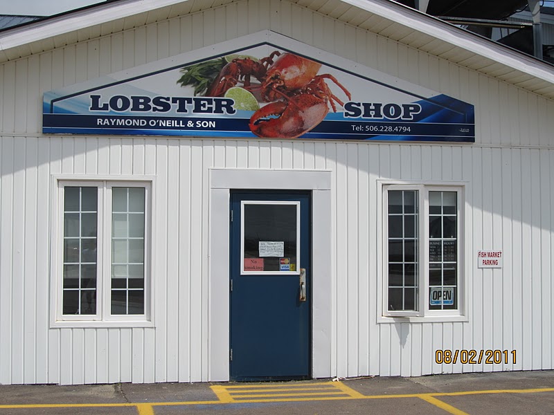
Lobster Shop

Lobster pots - getting ready for the next season

1959 Escuminac Disaster Memorial
 On 19 June 1959, a rare June hurricane sunk 22 boats (at sea) and 35 were drowned in the Gulf of St Lawrence.  The boats were from the port of Escuminac.  Wharves and breakwaters were damaged in the port as were vessels and fishing gear (trawls and lobster traps). It was a disaster for the town of 600.

Fishing vessels
The Acadians are the descendants of the 17th-century French colonists who settled in Acadia (located in the Canadian Maritime provincesNova Scotia, New Brunswick, and Prince Edward Island – as well as part of Quebec, and in the U.S. state of Maine).
Acadian Flag

The Tricolour represents the Motherland of the Acadians. The yellow star, the Stella Maris, is the symbol of Mary, Acadian national symbol and patron of the mariners. It is set on the blue stripe, because blue is the colour of Mary. The yellow colour of the star represents the Papacy

Escuminac Beach

Canadian visitors

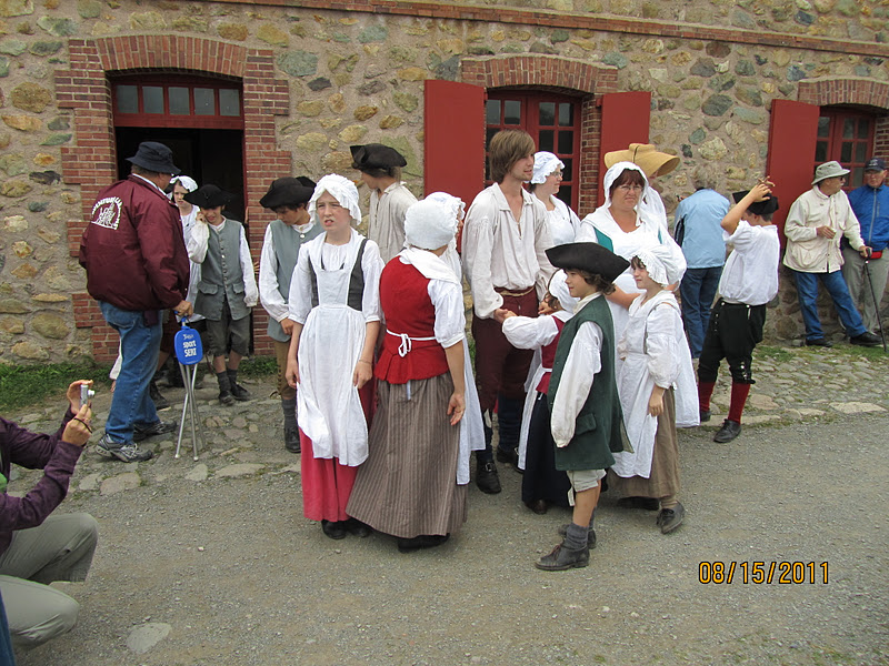
We spent several days in Escuminac waiting for the wind on the Northumberland Strait to fall off.  Every day people would drive around the harbor to see what was going on.  They'd drive right up next to the boat and chat with you.  Everyone was friendly and curious about where we'd come from and how we'd gotten there.  The group above are long time friends and were missionaries in Thailand for most of their adult lives.  The 4th lady in the group was a professor and was reluctant to climb down the ladder onto the boat.

We learned that diesel fuel was least expensive in the commercial marinas - too late for us!


5 August 2011 0647-1429  Escuminac to Shediac, New Brunswick  60nm

The most exciting part of this run was the entry into the marina.  The channel gets very narrow as you approach a 180 degree turn.  The breakwater is on your right.  We had a bit of wind making the entry that much more exciting.  Take a look at the three green navigation aids.

Approach into Point du Chene marina - Shediac, N.B.
Aloha Friday moored - Point du Chene marina

Royal Canadian Mounted Police - Canadian Coast Guard ship Louis M. Lauzier

CCGS Louis M. Lauzier
The CCG ship was having an open house so we took advantage of the opportunity to go aboard.  The Coast Guard runs the ship.  The vessel is used by the Royal Canadian Mounted Police (RCMP) and Sûreté du Québec (Quebec Provincial Police) to patrol the St. Lawrence Gulf and Seaway.  The CCGS Louis M. Lauzier is a component of the RCMP Marine Security Enforcement Team (MSET). The MSET was created in 2005 to assist in the identification of persons and vessels that may constitute a threat to the security of Canada and its communities. This threat includes terrorism, drug importation, the smuggling of weapons, cigarettes and alcohol, persons illegally entering the country as well as illegal waste discharge.  This initiative was made necessary due to the immense territory of the province of Québec and its geographic situation which makes it a gateway for criminal organizations.

Sunset - Point du Chene marina
They had free laundry at the marina so I took advantage of the opportunity to get some laundry done.


6 August 2011  0639-1135  Shediac, NB to Summerside, Prince Edward Island  33 nm

When we departed the next morning, it was under much calmer conditions.


You can see the edge of the breakwater on the port side of the boat.

Beautiful sunrise
We cross over to Prince Edward Island and moor at the Silver Fox Yacht Club, Summerside, PEI.


We spent the afternoon checking out Summerside.