From Quebec City to Rimouski we must take advantage of the flood running down the St Lawrence. Marinas on the St Lawrence are not close together. Neither of us speak French so I ask the marina in Quebec City to make a reservation at the next marina in Cap-a-l'Aigle. Hopefully applying this strategy at each marina will help with our language shortfall. Weather along the St Lawrence has also been a concern of mine; there really aren't a multitude of places to duck into if the weather turns nasty. So, having said that, here's how the trip played out.
19 Jul 2011 0656-1542 Quebec City to Cap-a-l'Aigle (Cape Eagle) - 72 nm
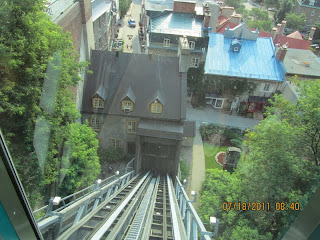
Based on our boat speed we depart 2 hours before high tide in Quebec City. We pass through the lock to exit the marina and leave the city of Quebec in our wake. We are "downbound" on the St Lawrence.
 |
| Quebec City |
Along the way we pass some freighters and ski slopes and enjoy a beautiful day on the water.
The Laurentian mountains parallel the coastline. These are the ski slopes of
Le Masif, the highest skiable slope in Quebec.
 |
| Le Masif |
 |
| Marina - Cap-a-l'Aigle |
20 Jul 2011 0949-1739 Cap-a-l'Aigle to L'Anse Saint Jean (St Jean Cove) 62 nm
Another major highlight on the trip was a cruise up the Saguenay fjord. Flood at the mouth of the Saguenay flows at 3-4 kts. Maximum ebb flows at 6-7 kts. So, again, we plan our departure from Cap-a-l'Aigle 1.5 hours after high tide at Point-au-Pere.
Before we entered the national park boundaries we saw several beluga whales. They are easy to pick out against a flat water background since they are a screaming white. Amazing to see! Too quick to take a picture.
 |
| Saguenay Fjord |
There are mooring balls available in Baie Eternite. Without knowing whether or not they are suitable for a 25 ton boat, we opted out.
 |
| Baie Eternite | |
 |
| Saguenay Fjord |
The pictures do not begin to convey the spectacular beauty here. This is a side trip off the St Lawrence. Leaving the St Lawrence at Tadoussac, one is immediately struck by the number of whale watching boats in the area. In the satellite photo below
La Baie is Baie Eternite. We stayed in a marina at L'Anse Saint Jean.
View Larger Map
The closest ATM was about 5 miles away so on a wet, rainy day we biked into town to get some cash.
It was a wet, hilly ride!
 |
| Covered Bridge |
 |
| The ride back... |
22 Jul 2011 1052-1720 L'Anse Saint Jean to Tadoussac (via Baie Eternite) 40 nm
Our intention was to stay at the marina in Tadoussac. However when I had one of the marina staff call to make a reservation, I was told first come, first serve. OK - fair enough. We get down there and start heading down the fairway into an empty spot and were told that we were too big! That turned out to be bogus since the Quebec cruising guide indicates they will take boats larger than ours. We suspect we were turned down because we were Anglophiles. Three sailboats we passed showed up within the hour and all 3 got dockage in the marina. Meanwhile we anchored in about 30' of water....You can see the marina in the "hook" of the Bay. Winds were predicted to be light that night. Good for us since we are exposed to the St Lawrence here.
View Larger Map
23 Jul 2011 0946-1736 Tadoussac to Rimouski 56 nm
We got underway in heavy fog. Visibility was less than 50 yds. This is where the radar and the Automatic Identification System (AIS) pay huge dividends. The radar shows us the traffic in the area, the AIS tells us the boat name, speed and direction. We monitored 5 small whale watching boats and 4 large cargo ships as we made our way out into the St Lawrence across the shipping lanes. The AIS allowed us to call the cargo ships to verify that they could see us on their radar. A little bit nerve wracking (for me) to say the least. 4 hours later the fog finally lifted! As if that were not enough for one day, the Canadian Coast Guard began issuing squall warnings on the VHF radio. We were hit with heavy rain, 50 kt plus winds and 4-6' square waves. Worst weather I have ever been in. Fortunately it only lasted an hour. We finally made in into Rimouski for the night. What a long, stressful day. I needed a day just to recuperate!
Our arrival into Rimouski crossed a weekend and on Sunday the Model Boat Club was out in full force.
 |
| Model boats - Rimouski |
 |
| More model boats |
Aloha Friday can be seen out on the face dock.
 |
| Rimouski marina |
There's also quite a large car ferry that crosses the Seaway to other side of the province of Quebec.
 |
Ferry to Forestville, Quebec
|
25 Jul 2011 0607-1224 Rimouski to Matane 44 nm
We no longer need to take advantage of the current on this part of the St Lawrence. However, the prevailing wisdom of those who have gone before us is to leave early and get in early so as to avoid an increase in wind and bad weather on the Seaway. That's our plan for the short term.
 |
| Matane marina |
The slip here is a little shorter than we are but it still works. With an early arrival into town, we have time to do a little exploring. The marina had bikes so we used theirs and rode into town to McDonalds (for a burger fix), over to the salmon fish laddar and generally rode around town. A fair number of men were fly fishing in the river.
26 Jul 2011 0602-1240 Matane to St-Anne-des-Monts 47 nm
The worlds tallest wind turbine (360') can be seen at Cap Chat (Cape Cat). This part of the coastline had many conventional wind turbines as well.
 |
| Tallest wind turbine - Cap Chat (pronounced Cap Shaw) |
All through the province we see beautiful, huge Catholic churches in these towns. Today was St Anne's feast day and Sainte-Anne-des-Monts (the name of the church as well as the town) had held a special Mass in remembrance.
 |
| Sainte-Anne-des-Monts Church |
27 Jul 2011 0608-1232 St-Anne-des-Monts to Riviere-Madeleine 48 nm
Riviere-Madeleine was the smallest "marina" we've stayed in to date. It was more of a fishing village than a marina. There was a range to guide us in and as you can see the whole place is pretty small. We are on the far left.
 |
| Range into Riviere Madeleine |
 |
| Riviere-Madeleine |
|
|
The coastline here was spectacular!
 |
Beautiful coastline
|
28 Jul 2011 0558-1125 Riviere-Madeleine to Riviere-au-Renard 40 nm
The last couple ports have been part of the Gaspe peninsula. We caught sight of our first whale on this stretch. I got a great shot of the tail.
 |
| Whale's Tail |
Riviere-au-Renard is a large commercial fishing port. We took a walking tour of the port and discovered that the nets are still repaired by hand.
 |
| Mending nets by hand |
Fishing boats.....


